The Cayuga Heights Sand Bank Company
|
Beginning in about 1920, Ithaca business owner Minos Mead Reynolds (1885-1931) took over the lease of a property on the hillside just below what would become Sunset Park from Cayuga Heights developer Jared T. Newman. Reynolds operated the Cayuga Heights Sand Bank company there for a little over a decade, and the site continued to be used to extract sand and gravel well until the 1950s. This surprising industrial feature in what is today an upscale Ithaca suburb has its roots in the glacial geology of the Finger Lakes region of New York.
|
Family Lands to Industrial Development
The property, on the southwestern boundary of the Village of Cayuga Heights, was originally part of Military Tract Lot Number 88. The Military Tract was the vast acreage that had been Haudenosaunnee territory before the Revolutionary War. This land was divided into 600-acre lots, which were given by lottery to soldiers who fought in the Revolutionary War.
In July 1790, Lot Number 88 was "balloted" to Captain Andrew Moodie of Lamb’s Artillery regiment. Lot 88 was in Township Number 22, then known as Ulysses. A later property document described it as "on the east side of the Lake road" at the southeast "corner" of Cayuga Lake.[1]
In July 1790, Lot Number 88 was "balloted" to Captain Andrew Moodie of Lamb’s Artillery regiment. Lot 88 was in Township Number 22, then known as Ulysses. A later property document described it as "on the east side of the Lake road" at the southeast "corner" of Cayuga Lake.[1]
The lot was to remain largely intact for more than a century. Captain Moodie sold Lot 88 to New York City merchant James Renwick (d. 1803) in December 1790. James Renwick never developed the land himself, but it was passed down to his children.[2] In 1894, the heirs of the Renwick family sold the property to Ithaca Street Railway investors Herman Bergholtz and Horace Hand. Bergholtz in turn divided up the land. He and his wife Adelina T. Bergholtz sold parts of it to Jared Newman and Charles Blood between 1901 and 1903.
Developing the Western Slope
It wasn't until after Newman and Blood had laid out the White Park section of their development that Newman himself turned his attention to planning the southwestern part of Cayuga Heights, what he would later call "the Western Slope."
In 1921, as part of a "Cayuga Heights Notes" advertisement in the Ithaca Journal, Newman described "the wooded slope" west of Cayuga Heights Road near Wyckoff Road as "a glorious spot, large enough and level enough for a specious [sic] building site, with nothing to cut off the view of town or lake or valley."[3]
In 1921, as part of a "Cayuga Heights Notes" advertisement in the Ithaca Journal, Newman described "the wooded slope" west of Cayuga Heights Road near Wyckoff Road as "a glorious spot, large enough and level enough for a specious [sic] building site, with nothing to cut off the view of town or lake or valley."[3]
The developer explained that he had been weighing whether to "reserve it for residential purposes, or to allow further excavation of sand and gravel" since the site sat atop "the largest available close-in deposit of these much needed materials." Newman noted that the sandbank spanned 80 feet of the hillside, with "nearly all of it good material." Such pockets of sand and gravel dot the Finger Lakes region and are the result of glacial action.

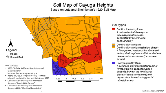
A soil survey conducted in 1920 showed that deposits of the Palmyra soil series underlie the area around Sunset Park. Palmyra soil is composed of sand and gravel that tends to form within glacially deposited sediment.
Ithaca was covered by glaciers during the last Ice Age. As the glaciers moved and eventually retreated, the glaciers modified the landscape and caused characteristic glacial soils to form. As glaciers move, they grind the bedrock underneath into sediment. This sediment–sand and gravel–flows out from underneath the glacier down to the terminus of the glacier, forming areas called outwash plains.
Glacial retreat can also release the sediment. As glaciers melt and retreat, they break up, forming crevasses and depressions in the surface of the ice. Sediment accumulates in these depressions and when the glacier melts, the piles of sediment are left behind, forming hills called kames. Kames and glacial outwash plains are the typical settings for the Palmyra soil to form.
Click on the image above to view a larger version of a soil map of Cayuga Heights based on data from 1920.
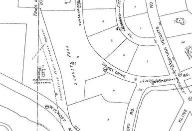
After consulting with an engineer and a landscape architect, Newman came up with a plan that would allow for the continued operation of the sand and gravel pit and the simultaneous development of home sites above it.
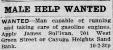
 Ad for the Cayuga Heights Sand Bank company, from the 1925 Manning's Ithaca phone directory.
The Reynolds company supplied sand and gravel for village roads and probably backfill for residential lots, so it was a beneficial arrangement for Newman and the developing community to see the company continue.
Reynolds operated the Cayuga Heights Sand Bank company for another decade, until his death in 1931.[4] Ruth Reynolds, Minos’s widow, sold the company in 1935, to E.M. Rumsey & Sons, owned by Hugh E. Rumsey and Ora L. Rumsey, operators of a sand and gravel pit near Buttermilk Falls.[5] Two decades later, in 1955, the owner of the lot below Sunset Park was accused of violating a Town of Ithaca ordinance by operating a sand pit “in a residential area in Renwick Heights,” so it appears that the site continued to be used for a few decades after Reynolds' death.[6]
Reynolds operated the Cayuga Heights Sand Bank company for another decade, until his death in 1931.[4] Ruth Reynolds, Minos’s widow, sold the company in 1935, to E.M. Rumsey & Sons, owned by Hugh E. Rumsey and Ora L. Rumsey, operators of a sand and gravel pit near Buttermilk Falls.[5] Two decades later, in 1955, the owner of the lot below Sunset Park was accused of violating a Town of Ithaca ordinance by operating a sand pit “in a residential area in Renwick Heights,” so it appears that the site continued to be used for a few decades after Reynolds' death.[6]
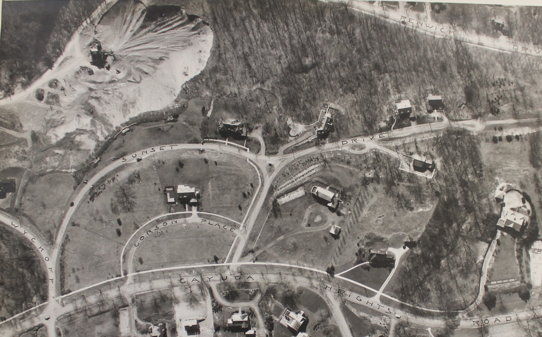
Today, thick vegetation covers the hillside below Sunset Park and frames architect-designed modern homes, obscuring any traces of the sand and gravel pit and Cayuga Heights' industrial history.
Patricia Longoria
Deputy Historian
August 2017
ENDNOTES
[1] M. Frances Ferris (compiler), The Balloting Book and Other Documents Relating to Military Bounty Lands in the State of New York, Albany, 1825; "Abstract of Title of That Part of 'Cayuga Heights' Which is Situated on Lot 88," furnished by Honorable S.D. Halliday to Messrs. Bergholtz and Hand, March 27, 1894.
[2] William Heidt, The Blue-eyed Lassie and the Renwicks in Ithaca, DeWitt Historical Society of Tompkins County, Ithaca, NY, 1970.
[3] Jared Newman, "Cayuga Heights Notes," Ithaca Journal, August 15, 1921.
[4] Reynolds Family Records, The History Center in Tompkins County; "Deaths and Funerals: Minos Mead Reynolds," Ithaca Journal, June 25, 1931.
[5] "Reynolds Sand Bank Bought by Rumsey," Ithaca Journal, March 15, 1935.
[6] "Decision Reserved in Zoning Cases," Ithaca Journal, August 1, 1955.


