Beginnings: Woodland Slopes and Upland Farms
The lands currently comprising the municipal boundaries of the Village of Cayuga Heights are part of the ancestral homeland of the Gayogohó:nǫˀ (Cayuga) people. Members of the Hodinǫhsǫ́:nih (Haudenosaunee Confederacy), Gayogohó:nǫˀ people recognize their historic and contemporary identity as tied to their origins “from the swampy land,” as their name is roughly translated, of the Cayuga Lake region. According to a review of archaeological research and Gayogohó:nǫˀ oral history by anthropologist Kurt Jordan, Gayogohó:nǫˀ people prospered across the abundant wetlands, wooded uplands, and fertile agricultural lands of the Cayuga Lake basin and today consider that “the whole region is basically one big ancestral site.”[1]
However, the American Revolution fundamentally disrupted Gayogohó:nǫˀ political control of their homelands, leaving a legacy of geographic displacement and a continuing struggle to maintain connection to the area. In 1779, the Sullivan-Clinton Expedition destroyed Gayogohó:nǫˀ villages around Cayuga Lake in order to cut off British support from the region. Subsequently the Gayogohó:nǫˀ territory became part of the Military Tract of Central New York, the enormous expanse of land that was divided into twenty-eight townships and then subdivided into 600-acre lots given to Revolutionary War veterans in 1790. The 1,164 acres of land of the Military Tract that became the Village of Cayuga Heights included portions of several lots, namely numbers 88, 89, and 90 in Township 22, Ulysses.[2]
However, the American Revolution fundamentally disrupted Gayogohó:nǫˀ political control of their homelands, leaving a legacy of geographic displacement and a continuing struggle to maintain connection to the area. In 1779, the Sullivan-Clinton Expedition destroyed Gayogohó:nǫˀ villages around Cayuga Lake in order to cut off British support from the region. Subsequently the Gayogohó:nǫˀ territory became part of the Military Tract of Central New York, the enormous expanse of land that was divided into twenty-eight townships and then subdivided into 600-acre lots given to Revolutionary War veterans in 1790. The 1,164 acres of land of the Military Tract that became the Village of Cayuga Heights included portions of several lots, namely numbers 88, 89, and 90 in Township 22, Ulysses.[2]
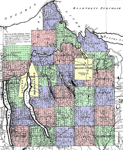 The Military Tract in 1792 Balloting Book Map
The intent of the land distribution was to encourage the establishment of farming communities, but many lot recipients never took up the land they were given. Much speculative buying and selling took place, and 88, 89, and 90 in Ulysses were no exception. Lot 88 on land sloping down to the southeast shore of Cayuga Lake in Ithaca was drawn by a Captain Andrew Moodie and eventually sold to the Renwick family, who held on to it for over a hundred years.[3] Lots 89 and 90, most of which fell on higher and flatter ground more suitable for farming than 88, were drawn by veterans named Lancaster Lighthall (Lot 89) and David Risley (Lot 90). Both lots changed hands, were broken up, and new owners, such as Isaac Cradit who bought property in the middle of lot 90, chopped down hundreds of trees, pulled out stumps, and plowed fields to convert the woodland into farms.
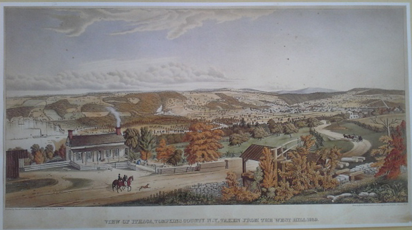 Henry Walton, “View of Ithaca, Tompkins County, Taken From the West Hill 1839,” Lithograph. Collection of The History Center in Tompkins County.
The period of settlement was one of many shifts in town and county boundary lines within the Military Tract. Ulysses Township, first drawn on the map of Onondaga County in 1794, became part of Cayuga County in 1799, Seneca County in 1804, and finally Tompkins County when it was created in April 1817.[4] In 1821, on 36 of the 580 total square miles of land in Tompkins County the Town of Ithaca was formed looping around the east, south and west sides of Cayuga Lake. The Village of Ithaca, which became the City of Ithaca in 1888, was in the center of the town fronting on the lake.[5] Establishment of the Town of Ithaca set in place the municipality within which the little Village of Cayuga Heights would be founded overlooking the east shore almost a century later.
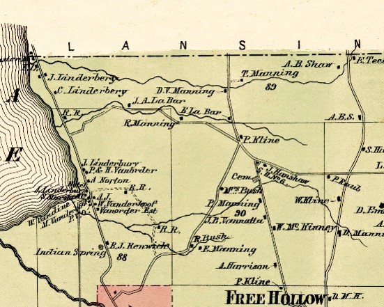 From “New Topographical Atlas of Tompkins County, New York. From actual surveys especially for this atlas,” Stone & Stewart, Philadelphia, 1866.
Like the rest of Tompkins County during the nineteenth century, when its population reached just over 12,000, almost all the land in the Town of Ithaca was farmed.[6] By the end of the Civil War in the little portion that would become Cayuga Heights roughly a dozen farms were clustered near what is known today as Community Corners at the junctions of Hanshaw, Pleasant Grove, East Upland, and North Triphammer roads. They ranged from small, subsistence operations to larger ones like the farm Isaac Cradit established and sold around 1860 to Peter Kline. Sixteen year-old Carrie Manning kept a diary in 1869 providing a unique chronicle of life on her family farm (marked as "T. Manning" on the map shown).[7]
Farming persisted well into the twentieth century around the Corners leaving behind a precious legacy of old houses interspersed among the hundreds built when Cayuga Heights became a suburb. The most important event in the nineteenth century for the future of the area was the founding of Cornell in 1865.
Farming persisted well into the twentieth century around the Corners leaving behind a precious legacy of old houses interspersed among the hundreds built when Cayuga Heights became a suburb. The most important event in the nineteenth century for the future of the area was the founding of Cornell in 1865.
Beatrice Szekely
Village Historian
2015 (updated 2023)
Village Historian
2015 (updated 2023)
ENDNOTES
[1] Kurt A. Jordan, The Gayogo̱hó:nǫʔ People in the Cayuga Lake Region; A Brief History (Tompkins County Historical Commission, 2022), 11.
[2] Map enclosed in The Balloting Book and Other Documents Relating to Military Bounty Lands in the State of New York (Albany: Packard & Van Benthuysen, 1815) at The John Marcham Library, The History Center at Tompkins County.
[3] William Heidt Jr., Ithaca City Historian, The Blue-Eyed Lassie and the Renwicks in Ithaca (Ithaca: DeWitt Historical Society of Tompkins County, 1970), 5.
[4] Jane Marsh Dieckmann, A Short History of Tompkins County (Dewitt Historical Society of Tompkins County, 1986), 38.
[5] Albert W. Force, “Town of Ithaca Separate Political Entity Since 1821,” Ithaca Journal, March 22, 1965, D-7.
[6] T. H. Hewitt, Landmarks of Tompkins County, New York, including a History of Cornell University, edited by John H. Selkreg (Syracuse, New York, 1976) 93-94 and 134-135.
[7] Carrie Manning’s Diary 1869, edited by William Heidt Jr. and adapted by Curtis Pfaff (Ithaca: DeWitt Historical Society of Tompkins County, Inc., 1962).
"Before the Village"
Centennial Speaker Series, 2015
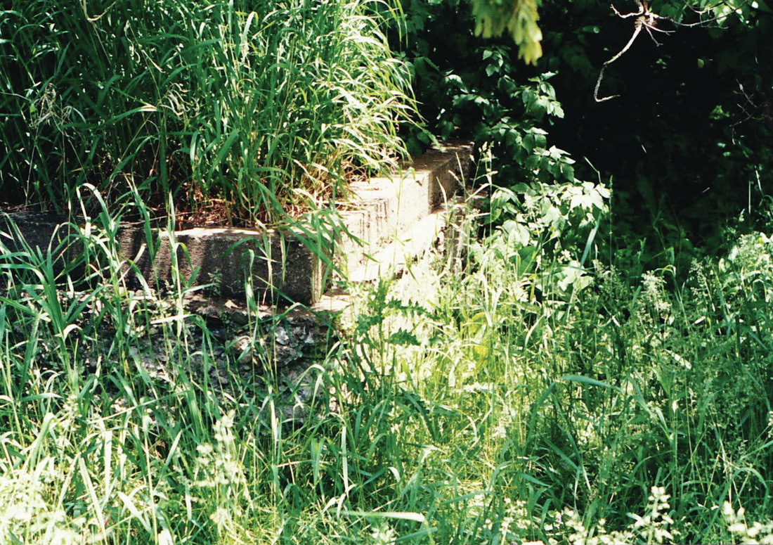 Remains of stone foundation of a bridge from a farmhouse on Hanshaw Road to barns
Before the Village
Beatrice Szekely, Municipal Historian, Village of Cayuga Heights
with Patricia Longoria, Deputy Historian
November 15, 2015, Marcham Hall, 836 Hanshaw Road
Village Historian Beatrice Szekely, a former village trustee and deputy mayor, and Deputy Historian Patricia Longoria will discuss their ongoing research into the eighteenth and nineteenth century foundations of the Village of Cayuga Heights. They will review how the intertwined histories of Native American settlement in Tompkins County and nineteenth century migration to the northeast region of Ithaca in the early 1800s have informed the Village's twentieth century development. Formally incorporated in 1915, Cayuga Heights was then a tiny streetcar suburb linked to Cornell University. Today it is known as a quintessential university suburb within the greater Ithaca area. Made possible, in part, by a Tompkins County Community Celebrations Grant.
|
"Before the Village" Part 1
|
"Before the Village" Part 2
|
"Before the Village" Part 3
|
"Before the Village" Slides
|